Sediment under Lake Chichancanab on the Yucatan Peninsula has offered scientists a clearer view of what happened to the Mayan civilization:
Scientists have several theories about why the collapse happened, including deforestation, overpopulation and extreme drought. New research, published in Science Thursday, focuses on the drought and suggests, for the first time, how extreme it was.
[S]cientists found a 50 percent decrease in annual precipitation over more than 100 years, from 800 to 1,000 A.D. At times, the study shows, the decrease was as much as 70 percent.
The drought was previously known, but this study is the first to quantify the rainfall, relative humidity and evaporation at that time. It's also the first to combine multiple elemental analyses and modeling to determine the climate record during the Mayan civilization demise.
Many theories about the drought triggers exist, but there is no smoking gun some 1,000 years later. The drought coincides with the beginning of the Medieval Warm Period, thought to have been caused by a decrease in volcanic ash in the atmosphere and an increase in solar activity. Previous studies have shown that the Mayans’ deforestation may have also contributed. Deforestation tends to decrease the amount of moisture and destabilize the soil. Additional theories for the cause of the drought include changes to the atmospheric circulation and decline in tropical cyclone frequency, Evans said.
What this research has to do with the early 21st Century I'll leave as an exercise for the reader.
When I get home tonight, I'll need to read these (and so should you):
And now, I'm off to the Art Institute.
Bloomberg published on Monday a super-cool analysis of U.S. land use patterns:
Using surveys, satellite images and categorizations from various government agencies, the U.S. Department of Agriculture divides the U.S. into six major types of land. The data can’t be pinpointed to a city block—each square on the map represents 250,000 acres of land. But piecing the data together state-by-state can give a general sense of how U.S. land is used.
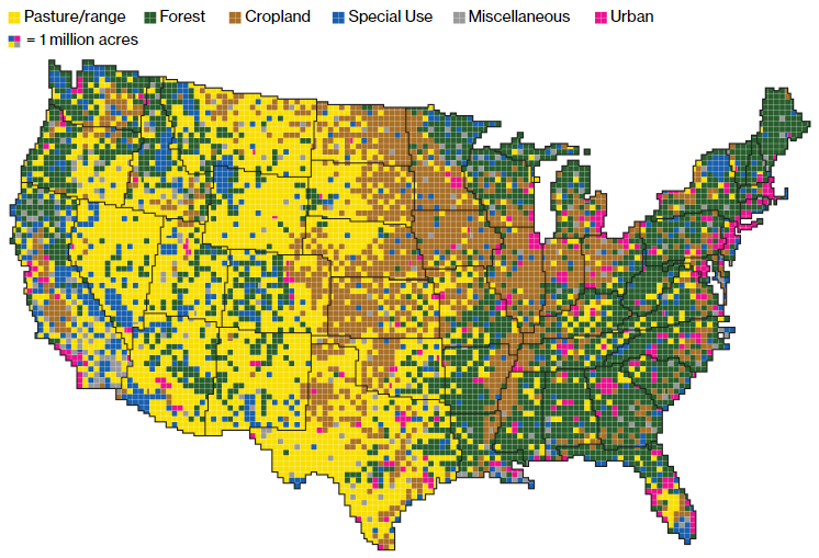
Gathered together, cropland would take up more than a fifth of the 48 contiguous states. Pasture and rangeland would cover most of the Western U.S., and all of the country’s cities and towns would fit neatly in the Northeast.
This is, of course, total Daily Parker bait.
Happy August! (Wait, where did April go?)
As I munch on my salad at my desk today, I'm reading these stories:
And finally, a bit of good news out of Half Moon Bay, Calif. The corporate owner of the local paper told them they had to shut down, so a group of townspeople formed a California benefit corporation to buy the paper out.